Understanding the quality and quantity of natural capital across a land area involves building a natural capital baseline. By using precision technology to assess land parcels, and the current and potential benefits they deliver to society and the environment, land managers can build a tangible benchmark on which to base future land management decisions.
Mapping Natural Capital
To create an accurate map of natural capital across farm or estate land, the first step is to obtain up-to-date satellite imagery of the land area.
As shown below, this bird’s eye view provides a broad understanding of the different aspects of natural capital within the boundary of a farm business. This includes fields, margins, hedgerows, woodland and water features.
This high-level baseline map was created using OS Master Map, which is easily access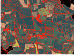 ible online, in conjunction with high-resolution satellite data - this can be trickier for farmers to get hold of.
Both types of map are needed to reproduce an accurate digital representation of land area to understand the quality of natural capital in more detail. However knowing which images are required and how to analyse the data can be complicated and costly.
Therefore, it can be very valuable to have the support of a remote sensing expert, who can help you access and make sense of the data.
Capturing detailed farmland data
To understand the potential of farm or estate landscapes in more detail, remote sensing technology is recommended to help measure and analyse the quality of available natural capital.
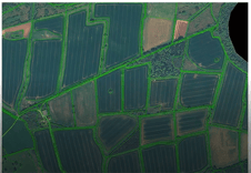
Remote sensors use geospatial science to capture data beyond our visible spectrum.
This means data captured by remote sensing devices goes above and beyond what is possible to capture with aerial photography, which is limited to the red, blue and green wavelengths we can see. The result is a high resolution image.
Understanding farmland biodiversity
High-resolution maps can be used to define ‘habitat parcels’ - distinct parcels of land which contain different habitat features for plants and wildlife.
To make sure the land maps that have been created remotely are as accurate as possible, it’s important to also carry out a scientific assessment of the habitat parcels on-farm.
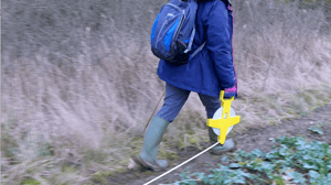
This is done by groundtruthing – which can involve using tools such as quadrats to practically measure the quality of biodiversity in different land parcels.
Within the LAND360 offering, ecologists visit farms or estates and carry out this process to verify that remote sensing results are at least 95% accurate.
Assessing natural capital
Once detailed data of farm or estate land has been collected, satellite imagery needs to be cross-referenced with a biodiversity metric tool to measure the types and volume of natural capital within field, margin and hedgerow habitats.
The habitats also need to be classified, which is often done using the free UKHAB system to assign specific codes, names and descriptions to each habitat parcel.
By assessing habitat conditions, and recording this against UKHAB criteria, farmers can gain insight into where land is supporting carbon storage and biodiversity. It could also highlight where there are opportunities to improve natural capital within specific parcels.
Learn more about the importance of harnessing biodiversity on farmland here.
A natural capital baseline
This process of assessing the quantity and quality of natural capital is crucial to make informed decisions around opportunities for protecting and investing in natural assets on-farm.
Just as every farmland map will be unique, the most appropriate strategy for harnessing natural capital will be different for each farmer or estate managers.
LAND360 utilises a range of software, scientific tools and multidisciplinary expertise to help farmers measure exactly what natural assets they have. Find out how it could benefit your business here.
