Fera Science’s LAND360 team helps farmers and landowners understand their natural capital baseline, providing information to adapt land management strategies and create sustainable farming businesses.
But what does this mean in practice, and how does LAND360 work? Fera Science's Glynn Jones, head of science (plant), answers your questions.
Why do we need to monitor natural capital?
On a national scale, the UK’s natural capital is degrading, meaning it’s not providing in an ecological or environmental way as it could be.
For farmers and land managers who rely on the land to produce crops and livestock, and for our society who want secure food supplies and to benefit from everything our landscapes offer, such as footpath access, flood prevention and carbon sequestration, improving our natural capital and ecosystems is critical.
Read more: What is natural capital?
What is LAND360, and how does it monitor natural capital?
LAND360 is a tiered service, with each tier offering a different approach to measuring and monitoring natural capital. LAND360 uses the expertise of the Fera team who identify solutions to help futureproof land-based businesses.
Our ecologists go onsite to assess biodiversity and measure hedgerows and trees to establish a picture of the quality of habitats that exist.
We have a remote sensing team who look at different aspects of the landscape in terms of canopy cover, species and linear features.
And we have a group of social scientists, who consider the objectives of the landowner and how they can interact with the incentive mechanisms in place to achieve environmental goals.
As part of the LAND360 service, Fera establishes a detailed baseline picture of the land and opportunities for future land management strategies. We can also work with the landowner to consider how business and personal objectives can be met.
You mentioned LAND360 is made up of tiers — what are they?
The three tiers of LAND360 are:
They are structured in a way that allows you to explore the natural capital on your land, understand the value of it, and identify future opportunities.
What is LAND360 Mapping+?
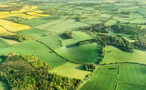
This is our entry-level, baselining service, which is delivered remotely. We use remote sensing technology, including very high-resolution satellite imagery, drones and aerial imagery to capture detailed information about a land area.
The satellite imagery we buy is based on tiles that are 25km2 and span the UK. Looking at clusters of farms can help farmers share the cost of images between businesses.
Once we have the imagery for a specific land area, the Fera Science team:
- Takes the satellite imagery and draws on all existing land features, such as the number of trees in an area
- Uses a classification system called UKHab to classify specific habitats to a high level of detail
- Uses carbon calculators to understand how much carbon is flowing through a habitat
- Uses Natural England’s biodiversity net gain calculator to calculate biodiversity net gain.
Read more: How can remote sensing technology help calculate natural capital?
What does LAND360 Scoring+ involve?
Scoring+ is about understanding the quality of the features we’ve identified in Mapping+.
Our team of ecologists go on-farm and use data from Mapping+ to validate and verify the information and look in more detail at the habitats available and those of specific interest.
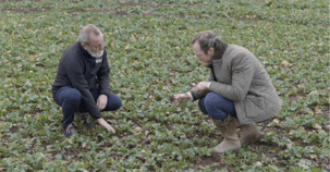
If you want to look at improving soil health, for example, we can build in tests and assessments to understand your soils.
This service uses a range of tools, technologies and expertise to assess the quality of the habitats and build an ecological score that can be used as a baseline.
And what about Ecosystem+?
Ecosystem+ is a consultancy tier, where we gather all the data we’ve generated, sit down with the farm or estate team and start to explore the range of options available for future land use.
By having an open conversation, we get to understand the business’ goals and come up with solutions for adapting the management of the farm or estate.
Sometimes a business’ options can be enormous, so we look at different scenarios. Doing a full economic analysis, we produce output maps to illustrate what impact any changes to land use could have economically and environmentally.
Ultimately, we’re creating data and information that empowers farmers and land managers to make their own decisions. Through our robust, science-based approach, we help inform the decision-making process and give people the clarity they need to see what options could work for them.
