Paul Brown, an expert in geospatial environmental data
As a senior remote sensing scientist and geomatics surveyor, I head up the remote sensing, GIS and spatial data science division within Fera’s land use and sustainability team, providing data insights for land managers and developers.
I joined Fera in 2014, having completed an undergraduate degree in geography at Loughborough and a Masters degree in remote sensing and geographic information systems (GIS) at Cranfield University.
Having been fortunate enough to gain a scholarship award from Infoterra, a provider of geospatial products, services and consultancy, for my master’s degree, I then went on to work for Infoterra, now Airbus Defence and Space for four years in their GIS, remote sensing and research and development teams.
I always had a passion for working in the environmental sector, so when an opportunity to join the Fera team came up, where I could help land use policy, whether public or private make more sustainable and environmental decisions, it was a no-brainer.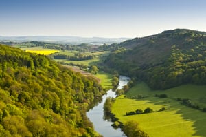
Combining science and data expertise to provide land insights
I’m trained in geomatic surveying, which involves measuring, collecting, and interpreting land data. This largely involves data acquisition, including ground control of environmental data with high resolution GNSS (Global Navigation Satellite Systems) positioning.
Ground control helps us to confirm that all the environmental data we’re collecting via practical biodiversity assessments on the ground and remote sensing data is positionally accurate to the highest degree required for the task.
This process ensures the legitimacy of the biodiversity data, adding to overall reliability and confidence in the information gathered. This is also an opportunity to identify and rectify any errors in the data.
Over the course of my career, I’ve also worked towards becoming a member of the Royal Institute of Chartered Surveyors, (RICS). As an organisation, RICS engages with the government on policy matters, and pushes for stronger biodiversity and sustainability measurers, influencing practice in the building sector.

Applying environmental expertise within our LAND360 service
As a research scientist at Fera, we have a long track record of supporting government and policy in monitoring and evaluating agri-environment schemes designed to support sustainability.
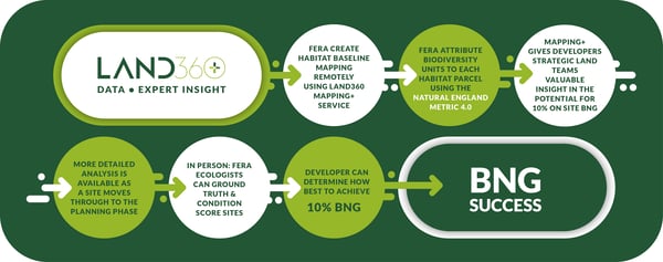
This is how the LAND360 methodology was developed - LAND360 is our natural capital assessment service that helps developers, farmers and land managers to accurately measure, manage and monitor land features, encompassing natural capital and biodiversity.
How LAND360 works with geospatial science
We start with collating baseline information, using geospatial data to investigate the range of habitats present across a development site, farmland, or estate.
Remote sensing allows us to interpret the landscape remotely using satellite data and by using geographic information systems (GIS) we can combine the land mapping, derived for the satellite data, with ecological assessments. This data is directly compatible with the Natural England Biodiversity Metric 4.0 at different stages throughout the process, giving insights at different decision-making points.
We’re able to assess the quality and quantity of the habitats - from the amount of biodiversity in each parcel of land, to the amount of carbon that’s being stored.
Insights on biodiversity net gain and natural capital opportunities
The high quality geospatial data insights we gain through the LAND360 habitat assessment are incredibly valuable when it comes to investigating biodiversity net gain opportunities for developers, guiding BNG plans.
 Working with farmers and land managers, we also help pinpoint where agricultural land could potentially be used in a smarter way and which income opportunities, such as BNG investment, could be best suited to the business.
It’s great to be a part of a team that helps developers and land managers to investigate, visualise and action different management options that prioritise environmental sustainability.
Capturing, monitoring and understanding geospatial data is vital to making more informed decisions and delivering greater environmental outcomes.
To read more from Paul, check out the blogs below where he shares his expert advice on the role of science in sustainable land management and BNG planning.
More about LAND360
LAND360 is Fera's cutting-edge natural capital assessment service. Launched in 2022, it empowers farmers, landowners, estate managers, and housing developers to make informed land use decisions. By accurately measuring and mapping existing land habitat features and modelling biodiversity offerings, LAND360 is a vital tool in the quest for sustainable development and biodiversity enhancement.


